


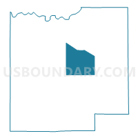
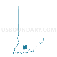
MARION 02, Dubois County, Indiana
About
Outline

Summary
| Unique Area Identifier | 576958 |
| Name | MARION 02 |
| County | Dubois County |
| State | Indiana |
| Area (square miles) | 22.61 |
| Land Area (square miles) | 22.10 |
| Water Area (square miles) | 0.51 |
| % of Land Area | 97.75 |
| % of Water Area | 2.25 |
| Latitude of the Internal Point | 38.38913100 |
| Longtitude of the Internal Point | -86.82510570 |
Maps

Graphs
Select a template below for downloading or customizing gragh for MARION 02, Dubois County, Indiana


Neighbors
Neighoring Voting District (by Name) Neighboring Voting District on the Map
- BAINBRIDGE 01, Dubois County, IN
- BAINBRIDGE 07, Dubois County, IN
- HALL 01, Dubois County, IN
- JACKSON 01, Dubois County, IN
- JACKSON 02, Dubois County, IN
- MARION 01, Dubois County, IN
Top 10 Neighboring County Subdivision (by Population) Neighboring County Subdivision on the Map
- Bainbridge township, Dubois County, IN (16,020)
- Jackson township, Dubois County, IN (2,125)
- Marion township, Dubois County, IN (1,501)
- Hall township, Dubois County, IN (1,281)
Top 10 Neighboring Unified School District (by Population) Neighboring Unified School District on the Map
- Greater Jasper Consolidated Schools, IN (19,515)
- Southeast Dubois County School Corporation, IN (7,297)
- Northeast Dubois County School Corporation, IN (5,435)